TM21: Speed Harmonization
This service package determines speed recommendations based on traffic conditions and weather information and uses connected vehicle technologies to assist in harmonizing speeds to these recommendations. The speed recommendations can be regulatory (e.g. variable speed limits) or advisory. The purpose of speed harmonization is to change traffic speed on links that approach areas of traffic congestion, bottlenecks, incidents, special events, and other conditions that affect flow. Speed harmonization assists in maintaining flow, reducing unnecessary stops and starts, and maintaining consistent speeds. The service package utilizes connected vehicle V2I communication to detect the precipitating roadway or congestion conditions that might necessitate speed harmonization, to generate the appropriate response plans and speed recommendation strategies for upstream traffic, and to broadcast such recommendations to the affected vehicles. The speed recommendations can be provided in-vehicle for connected vehicles, or through roadside signage for non-connected vehicles.
Relevant Regions: Australia, Canada, European Union, and United States
- Enterprise
- Functional
- Physical
- Goals and Objectives
- Needs and Requirements
- Sources
- Security
- Standards
- System Requirements
Enterprise
Development Stage Roles and Relationships
Installation Stage Roles and Relationships
Operations and Maintenance Stage Roles and Relationships
(hide)
| Source | Destination | Role/Relationship |
|---|---|---|
| Connected Vehicle Roadside Equipment Maintainer | Connected Vehicle Roadside Equipment | Maintains |
| Connected Vehicle Roadside Equipment Manager | Connected Vehicle Roadside Equipment | Manages |
| Connected Vehicle Roadside Equipment Owner | Connected Vehicle Roadside Equipment Maintainer | System Maintenance Agreement |
| Connected Vehicle Roadside Equipment Owner | Connected Vehicle Roadside Equipment Manager | Operations Agreement |
| Connected Vehicle Roadside Equipment Owner | Driver | Application Usage Agreement |
| Connected Vehicle Roadside Equipment Owner | ITS Roadway Equipment Maintainer | Maintenance Data Exchange Agreement |
| Connected Vehicle Roadside Equipment Owner | ITS Roadway Equipment Owner | Information Exchange and Action Agreement |
| Connected Vehicle Roadside Equipment Owner | ITS Roadway Equipment User | Service Usage Agreement |
| Connected Vehicle Roadside Equipment Owner | Traffic Management Center Maintainer | Maintenance Data Exchange Agreement |
| Connected Vehicle Roadside Equipment Owner | Traffic Management Center Owner | Information Exchange and Action Agreement |
| Connected Vehicle Roadside Equipment Owner | Traffic Management Center User | Service Usage Agreement |
| Connected Vehicle Roadside Equipment Owner | Traffic Operations Personnel | Application Usage Agreement |
| Connected Vehicle Roadside Equipment Owner | Vehicle Maintainer | Maintenance Data Exchange Agreement |
| Connected Vehicle Roadside Equipment Owner | Vehicle Owner | Information Exchange and Action Agreement |
| Connected Vehicle Roadside Equipment Owner | Vehicle User | Service Usage Agreement |
| Connected Vehicle Roadside Equipment Supplier | Connected Vehicle Roadside Equipment Owner | Warranty |
| Driver | Vehicle | Operates |
| ITS Roadway Equipment Maintainer | ITS Roadway Equipment | Maintains |
| ITS Roadway Equipment Manager | ITS Roadway Equipment | Manages |
| ITS Roadway Equipment Owner | Connected Vehicle Roadside Equipment Maintainer | Maintenance Data Exchange Agreement |
| ITS Roadway Equipment Owner | Connected Vehicle Roadside Equipment Owner | Information Exchange and Action Agreement |
| ITS Roadway Equipment Owner | Connected Vehicle Roadside Equipment User | Service Usage Agreement |
| ITS Roadway Equipment Owner | ITS Roadway Equipment Maintainer | System Maintenance Agreement |
| ITS Roadway Equipment Owner | ITS Roadway Equipment Manager | Operations Agreement |
| ITS Roadway Equipment Owner | Traffic Management Center Maintainer | Maintenance Data Exchange Agreement |
| ITS Roadway Equipment Owner | Traffic Management Center Owner | Information Exchange and Action Agreement |
| ITS Roadway Equipment Owner | Traffic Management Center User | Service Usage Agreement |
| ITS Roadway Equipment Owner | Traffic Operations Personnel | Application Usage Agreement |
| ITS Roadway Equipment Supplier | ITS Roadway Equipment Owner | Warranty |
| Traffic Management Center Maintainer | Traffic Management Center | Maintains |
| Traffic Management Center Manager | Traffic Management Center | Manages |
| Traffic Management Center Manager | Traffic Operations Personnel | System Usage Agreement |
| Traffic Management Center Owner | Connected Vehicle Roadside Equipment Maintainer | Maintenance Data Exchange Agreement |
| Traffic Management Center Owner | Connected Vehicle Roadside Equipment Owner | Information Provision Agreement |
| Traffic Management Center Owner | Connected Vehicle Roadside Equipment User | Service Usage Agreement |
| Traffic Management Center Owner | ITS Roadway Equipment Maintainer | Maintenance Data Exchange Agreement |
| Traffic Management Center Owner | ITS Roadway Equipment Owner | Information Provision Agreement |
| Traffic Management Center Owner | ITS Roadway Equipment User | Service Usage Agreement |
| Traffic Management Center Owner | Traffic Management Center Maintainer | System Maintenance Agreement |
| Traffic Management Center Owner | Traffic Management Center Manager | Operations Agreement |
| Traffic Management Center Owner | Transportation Information Center Maintainer | Maintenance Data Exchange Agreement |
| Traffic Management Center Owner | Transportation Information Center Owner | Information Provision Agreement |
| Traffic Management Center Owner | Transportation Information Center User | Service Usage Agreement |
| Traffic Management Center Supplier | Traffic Management Center Owner | Warranty |
| Traffic Operations Personnel | Traffic Management Center | Operates |
| Transportation Information Center Maintainer | Transportation Information Center | Maintains |
| Transportation Information Center Manager | Transportation Information Center | Manages |
| Transportation Information Center Owner | Driver | Application Usage Agreement |
| Transportation Information Center Owner | Transportation Information Center Maintainer | System Maintenance Agreement |
| Transportation Information Center Owner | Transportation Information Center Manager | Operations Agreement |
| Transportation Information Center Owner | Vehicle Maintainer | Maintenance Data Exchange Agreement |
| Transportation Information Center Owner | Vehicle Owner | Information Provision Agreement |
| Transportation Information Center Owner | Vehicle User | Service Usage Agreement |
| Transportation Information Center Supplier | Transportation Information Center Owner | Warranty |
| Vehicle Characteristics Maintainer | Vehicle Characteristics | Maintains |
| Vehicle Characteristics Manager | Vehicle Characteristics | Manages |
| Vehicle Characteristics Owner | Vehicle Characteristics Maintainer | System Maintenance Agreement |
| Vehicle Characteristics Owner | Vehicle Characteristics Manager | Operations Agreement |
| Vehicle Characteristics Supplier | Vehicle Characteristics Owner | Warranty |
| Vehicle Maintainer | Vehicle | Maintains |
| Vehicle Manager | Driver | System Usage Agreement |
| Vehicle Manager | Vehicle | Manages |
| Vehicle Owner | Connected Vehicle Roadside Equipment Maintainer | Maintenance Data Exchange Agreement |
| Vehicle Owner | Connected Vehicle Roadside Equipment Owner | Expectation of Data Provision |
| Vehicle Owner | Connected Vehicle Roadside Equipment User | Service Usage Agreement |
| Vehicle Owner | Vehicle Maintainer | System Maintenance Agreement |
| Vehicle Owner | Vehicle Manager | Operations Agreement |
| Vehicle Supplier | Vehicle Owner | Warranty |
Functional
This service package includes the following Functional View PSpecs:
Physical
The physical diagram can be viewed in SVG or PNG format and the current format is SVG.SVG Diagram
PNG Diagram
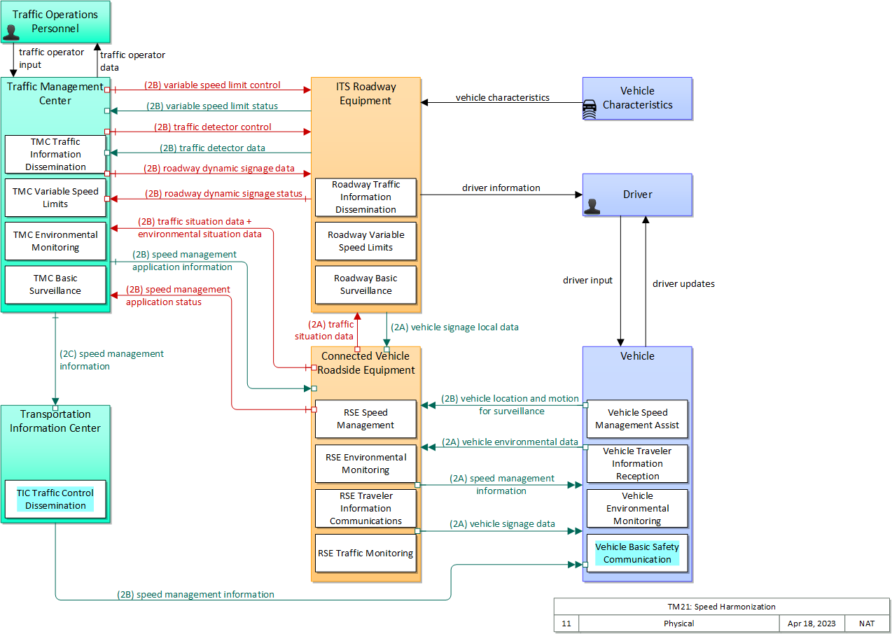
Includes Physical Objects:
| Physical Object | Class | Description |
|---|---|---|
| Connected Vehicle Roadside Equipment | Field | 'Connected Vehicle Roadside Equipment' (CV RSE) represents the Connected Vehicle roadside devices (i.e., Roadside Units (RSUs)) equipped with short range wireless (SRW) communications technology, as well as any other supporting equipment that leverage the RSU and are not described by other objects (e.g., a local roadside processor). CVRSE are used to send messages to, and receive messages from, nearby vehicles and personal devices equipped with compatible communications technology. Communications with adjacent field equipment and back office centers that monitor and control the RSE are also supported. This device operates from a fixed position and may be permanently deployed or a portable device that is located temporarily in the vicinity of a traffic incident, road construction, or a special event. It includes a processor, data storage, and communications capabilities that support secure communications with passing vehicles, other field equipment, and centers. |
| Driver | Vehicle | The 'Driver' represents the person that operates a vehicle on the roadway. Included are operators of private, transit, commercial, and emergency vehicles where the interactions are not particular to the type of vehicle (e.g., interactions supporting vehicle safety applications). The Driver originates driver requests and receives driver information that reflects the interactions which might be useful to all drivers, regardless of vehicle classification. Information and interactions which are unique to drivers of a specific vehicle type (e.g., fleet interactions with transit, commercial, or emergency vehicle drivers) are covered by separate objects. |
| ITS Roadway Equipment | Field | 'ITS Roadway Equipment' represents the ITS equipment that is distributed on and along the roadway that monitors and controls traffic and monitors and manages the roadway. This physical object includes traffic detectors, environmental sensors, traffic signals, highway advisory radios, dynamic message signs, CCTV cameras and video image processing systems, grade crossing warning systems, and ramp metering systems. Lane management systems and barrier systems that control access to transportation infrastructure such as roadways, bridges and tunnels are also included. This object also provides environmental monitoring including sensors that measure road conditions, surface weather, and vehicle emissions. Work zone systems including work zone surveillance, traffic control, driver warning, and work crew safety systems are also included. |
| Traffic Management Center | Center | The 'Traffic Management Center' monitors and controls traffic and the road network. It represents centers that manage a broad range of transportation facilities including freeway systems, rural and suburban highway systems, and urban and suburban traffic control systems. It communicates with ITS Roadway Equipment and Connected Vehicle Roadside Equipment (RSE) to monitor and manage traffic flow and monitor the condition of the roadway, surrounding environmental conditions, and field equipment status. It manages traffic and transportation resources to support allied agencies in responding to, and recovering from, incidents ranging from minor traffic incidents through major disasters. |
| Traffic Operations Personnel | Center | 'Traffic Operations Personnel' represents the people that operate a traffic management center. These personnel interact with traffic control systems, traffic surveillance systems, incident management systems, work zone management systems, and travel demand management systems. They provide operator data and command inputs to direct system operations to varying degrees depending on the type of system and the deployment scenario. |
| Transportation Information Center | Center | The 'Transportation Information Center' collects, processes, stores, and disseminates transportation information to system operators and the traveling public. The physical object can play several different roles in an integrated ITS. In one role, the TIC provides a data collection, fusing, and repackaging function, collecting information from transportation system operators and redistributing this information to other system operators in the region and other TICs. In this information redistribution role, the TIC provides a bridge between the various transportation systems that produce the information and the other TICs and their subscribers that use the information. The second role of a TIC is focused on delivery of traveler information to subscribers and the public at large. Information provided includes basic advisories, traffic and road conditions, transit schedule information, yellow pages information, ride matching information, and parking information. The TIC is commonly implemented as a website or a web-based application service, but it represents any traveler information distribution service. |
| Vehicle | Vehicle | This 'Vehicle' physical object is used to model core capabilities that are common to more than one type of Vehicle. It provides the vehicle-based general sensory, processing, storage, and communications functions that support efficient, safe, and convenient travel. Many of these capabilities (e.g., see the Vehicle Safety service packages) apply to all vehicle types including personal vehicles, commercial vehicles, emergency vehicles, transit vehicles, and maintenance vehicles. From this perspective, the Vehicle includes the common interfaces and functions that apply to all motorized vehicles. The radio(s) supporting V2V and V2I communications are a key component of the Vehicle. Both one-way and two-way communications options support a spectrum of information services from basic broadcast to advanced personalized information services. Advanced sensors, processors, enhanced driver interfaces, and actuators complement the driver information services so that, in addition to making informed mode and route selections, the driver travels these routes in a safer and more consistent manner. This physical object supports all six levels of driving automation as defined in SAE J3016. Initial collision avoidance functions provide 'vigilant co-pilot' driver warning capabilities. More advanced functions assume limited control of the vehicle to maintain lane position and safe headways. In the most advanced implementations, this Physical Object supports full automation of all aspects of the driving task, aided by communications with other vehicles in the vicinity and in coordination with supporting infrastructure subsystems. |
| Vehicle Characteristics | Vehicle | 'Vehicle Characteristics' represents the external view of individual vehicles of any class from cars and light trucks up to large commercial vehicles and down to micromobility vehicles (MMVs). It includes vehicle physical characteristics such as height, width, length, weight, and other properties (e.g., magnetic properties, number of axles) of individual vehicles that can be sensed and measured or classified. This physical object represents the physical properties of vehicles that can be sensed by vehicle-based or infrastructure-based sensors to support vehicle automation and traffic sensor systems. The analog properties provided by this terminator represent the sensor inputs that are used to detect and assess vehicle(s) within the sensor's range to support safe AV operation and/or responsive and safe traffic management. |
Includes Functional Objects:
| Functional Object | Description | Physical Object |
|---|---|---|
| Roadway Basic Surveillance | 'Roadway Basic Surveillance' monitors traffic conditions using fixed equipment such as loop detectors and CCTV cameras. | ITS Roadway Equipment |
| Roadway Traffic Information Dissemination | 'Roadway Traffic Information Dissemination' includes field elements that provide information to drivers, including dynamic message signs and highway advisory radios. | ITS Roadway Equipment |
| Roadway Variable Speed Limits | 'Roadway Variable Speed Limits' includes the field equipment, physical overhead lane signs and associated control electronics that are used to manage and control variable speed limits systems. This equipment monitors traffic and environmental conditions along the roadway. The system can be centrally monitored and controlled by a Traffic Management Center or it can be autonomous, calculating and setting suitable speed limits, usually by lane. This application displays the speed limits and additional information such as basic safety rules and current traffic information to drivers. | ITS Roadway Equipment |
| RSE Environmental Monitoring | 'RSE Environmental Monitoring' collects environmental situation (probe) data from passing vehicles that are equipped with short range communications capability. The collected data includes current environmental conditions as measured by on-board sensors (e.g., ambient temperature and precipitation measures), current status of vehicle systems that can be used to infer environmental conditions (e.g., status of lights, wipers, ABS, and traction control systems), and emissions measures reported by the vehicle. The functional object collects the provided data, aggregates and filters the data based on provided configuration parameters, and sends the collected information back to a center for processing and distribution. This functional object may also process the collected data locally and issue short-term road weather advisories for the road segment using short range communications. | Connected Vehicle Roadside Equipment |
| RSE Speed Management | 'RSE Speed Management' provides infrastructure information including road grade, roadway geometry, road weather information, and current speed limits to assist vehicles in maintaining safe speeds and headways. It also provides speed recommendations to vehicles based on current conditions and overall speed limits and strategies established by the back office. | Connected Vehicle Roadside Equipment |
| RSE Traffic Monitoring | 'RSE Traffic Monitoring' monitors the basic safety messages that are shared between connected vehicles and distills this data into traffic flow measures that can be used to manage the network in combination with or in lieu of traffic data collected by infrastructure-based sensors. As connected vehicle penetration rates increase, the measures provided by this application can expand beyond vehicle speeds that are directly reported by vehicles to include estimated volume, occupancy, and other measures. This object also supports incident detection by monitoring for changes in speed and vehicle control events that indicate a potential incident. | Connected Vehicle Roadside Equipment |
| RSE Traveler Information Communications | 'RSE Traveler Information Communications' includes field elements that distribute information to vehicles for in-vehicle display. The information may be provided by a center (e.g., variable information on traffic and road conditions in the vicinity of the field equipment) or it may be determined and output locally (e.g., static sign information and signal phase and timing information). This includes the interface to the center or field equipment that controls the information distribution and the short range communications equipment that provides information to passing vehicles. | Connected Vehicle Roadside Equipment |
| TIC Traffic Control Dissemination | 'TIC Traffic Control Dissemination' disseminates intersection status, lane control information, special vehicle alerts, and other traffic control related information that is real-time or near real-time in nature and relevant to vehicles in a relatively local area on the road network. It collects traffic control information from Traffic Management and other Center(s) and disseminates the relevant information to vehicles and other mobile devices. | Transportation Information Center |
| TMC Basic Surveillance | 'TMC Basic Surveillance' remotely monitors and controls traffic sensor systems and surveillance (e.g., CCTV) equipment, and collects, processes and stores the collected traffic data. Current traffic information and other real-time transportation information is also collected from other centers. The collected information is provided to traffic operations personnel and made available to other centers. | Traffic Management Center |
| TMC Environmental Monitoring | 'TMC Environmental Monitoring' assimilates current and forecast road conditions and surface weather information using a combination of weather service provider information, information collected by other centers such as the Maintenance and Construction Management Center, data collected from environmental sensors deployed on and about the roadway, and information collected from connected vehicles. The collected environmental information is monitored and presented to the operator. This information can be used to issue general traveler advisories and support location specific warnings to drivers. | Traffic Management Center |
| TMC Traffic Information Dissemination | 'TMC Traffic Information Dissemination' disseminates traffic and road conditions, closure and detour information, incident information, driver advisories, and other traffic-related data to other centers, the media, and driver information systems. It monitors and controls driver information system field equipment including dynamic message signs and highway advisory radio, managing dissemination of driver information through these systems. | Traffic Management Center |
| TMC Variable Speed Limits | 'TMC Variable Speed Limits' provides center monitoring and control of variable speed limits systems. It monitors data on traffic and environmental conditions collected from sensors along the roadway. Based on the measured data, it calculates and sets suitable speed limits usually by lane. It controls equipment that posts the current speed limits and displays additional information such as basic safety rules and current traffic information to drivers. | Traffic Management Center |
| Vehicle Basic Safety Communication | 'Vehicle Basic Safety Communication' exchanges current vehicle characteristics, location, and motion (including past and intended maneuver) information with other vehicles in the vicinity, uses that information to calculate vehicle paths, and warns the driver when the potential for an impending collision is detected. If available, map data is used to filter and interpret the relative location and motion of vehicles in the vicinity. Information from on-board sensors (e.g., radars and image processing) are also used, if available, in combination with the V2V communications to detect non-equipped vehicles and corroborate connected vehicle data. This object represents a broad range of implementations ranging from basic Vehicle Awareness Devices that only broadcast vehicle location and motion and provide no driver warnings to advanced integrated safety systems that coordinate maneuvers and may, in addition to warning the driver, provide collision warning information to support automated control functions that can support control intervention. | Vehicle |
| Vehicle Environmental Monitoring | 'Vehicle Environmental Monitoring' collects data from on-board sensors and systems related to environmental conditions and sends the collected data to the infrastructure as the vehicle travels. The collected data is a byproduct of vehicle safety and convenience systems and includes ambient air temperature and precipitation measures and status of the wipers, lights, ABS, and traction control systems. | Vehicle |
| Vehicle Speed Management Assist | 'Vehicle Speed Management Assist' assists the driver in operating the vehicle within the current speed limit. It monitors current vehicle speed and communicates with the infrastructure to receive current speed limits and associated road configuration change notifications. Driver warnings are issued when unsafe or excessive speeds are detected based on the provided speed limits and current conditions. | Vehicle |
| Vehicle Traveler Information Reception | 'Vehicle Traveler Information Reception' receives advisories, vehicle signage data, and other driver information of use to all types of vehicles and drivers and presents this information to the driver using in-vehicle equipment. Information presented may include fixed sign information, traffic control device status (e.g., signal phase and timing data), advisory and detour information, warnings of adverse road and weather conditions, travel times, and other driver information. | Vehicle |
Includes Information Flows:
| Information Flow | Description |
|---|---|
| driver information | Regulatory, warning, guidance, and other information provided to the driver to support safe and efficient vehicle operation. |
| driver input | Driver input to the vehicle on-board equipment including configuration data, settings and preferences, interactive requests, and control commands. |
| driver updates | Information provided to the driver including visual displays, audible information and warnings, and haptic feedback. The updates inform the driver about current conditions, potential hazards, and the current status of vehicle on-board equipment. |
| environmental situation data | Aggregated and filtered vehicle environmental data collected from vehicle safety and convenience systems including measured air temperature, exterior light status, wiper status, sun sensor status, rain sensor status, traction control status, anti-lock brake status, and other collected vehicle system status and sensor information. This information flow represents the aggregated and filtered environmental data sets that are provided by the RSE to the back office center. Depending on the RSE configuration and implementation, the data set may also include environmental sensor station data collected by the RSE. |
| roadway dynamic signage data | Information used to initialize, configure, and control dynamic message signs. This flow can provide message content and delivery attributes, local message store maintenance requests, control mode commands, status queries, and all other commands and associated parameters that support remote management of these devices. |
| roadway dynamic signage status | Current operating status of dynamic message signs. |
| speed management application information | Current speed targets, advisories, and limits including time of day, week, or season speed limits as necessary, and application parameters and thresholds. This flow also supports remote control of the application so the application can be taken offline, reset, or restarted. |
| speed management application status | Speed management application status reported by the RSE. This includes current operational state and status of the RSE and a record of measured vehicle speeds and current speed targets, advisories, and limits. |
| speed management information | Target speeds, speed advisories, and/or speed limit information provided to a vehicle. The information includes the current speed value(s), the route segment(s) and lane(s) where the speeds apply, and an indication of whether the speeds are suggested target speeds, posted advisory speeds, or enforceable speed limit values. This flow may also include information about the reason for reduced speeds and provide target lane information if lane changes are required. |
| traffic detector control | Information used to configure and control traffic detector systems such as inductive loop detectors and machine vision sensors. |
| traffic detector data | Raw and/or processed traffic detector data which allows derivation of traffic flow variables (e.g., speed, volume, and density measures) and associated information (e.g., congestion, potential incidents). This flow includes the traffic data and the operational status of the traffic detectors |
| traffic operator data | Presentation of traffic operations data to the operator including traffic conditions, current operating status of field equipment, maintenance activity status, incident status, video images, security alerts, emergency response plan updates and other information. This data keeps the operator appraised of current road network status, provides feedback to the operator as traffic control actions are implemented, provides transportation security inputs, and supports review of historical data and preparation for future traffic operations activities. |
| traffic operator input | User input from traffic operations personnel including requests for information, configuration changes, commands to adjust current traffic control strategies (e.g., adjust signal timing plans, change DMS messages), and other traffic operations data entry. |
| traffic situation data | Current, aggregate traffic data collected from connected vehicles that can be used to supplement or replace information collected by roadside traffic detectors. It includes raw and/or processed reported vehicle speeds, counts, and other derived measures. Raw and/or filtered vehicle control events may also be included to support incident detection. |
| variable speed limit control | Information used to configure and control variable speed limit systems including the equipment used to provide current speed limits and other information to drivers. |
| variable speed limit status | Current operating status of the variable speed limit systems including the state of the equipment. |
| vehicle characteristics | The physical or visible characteristics of individual vehicles that can be used to detect, classify, and monitor vehicles and imaged to uniquely identify vehicles. |
| vehicle environmental data | Data from vehicle safety and convenience systems that can be used to estimate environmental and infrastructure conditions, including measured air temperature, exterior light status, wiper status, sun sensor status, rain sensor status, traction control status, anti-lock brake status, vertical acceleration and other collected vehicle system status and sensor information. The collected data is reported along with the location, heading, and time that the data was collected. Both current data and snapshots of recent events (e.g., traction control or anti-lock brake system activations) may be reported. |
| vehicle location and motion for surveillance | Data describing the vehicle's location in three dimensions, heading, speed, acceleration, braking status, and size. This flow represents monitoring of basic safety data ('vehicle location and motion') broadcast by passing connected vehicles for use in vehicle detection and traffic monitoring applications. |
| vehicle signage data | In-vehicle signing data that augments regulatory, warning, and informational road signs and signals. The information provided would include static sign information (e.g., stop, curve warning, guide signs, service signs, and directional signs) and dynamic information (e.g., local traffic and road conditions, restrictions, vehicle requirements, work zones, detours, closures, advisories, and warnings). |
| vehicle signage local data | Information provided by adjacent field equipment to support in-vehicle signing of dynamic information that is currently being displayed to passing drivers. This includes the dynamic information (e.g., local traffic and road conditions, work zone information, lane restrictions, detours, closures, advisories, parking availability, etc.) and control parameters that identify the desired timing, duration, and priority of the signage data. |
Goals and Objectives
Associated Planning Factors and Goals
| Planning Factor | Goal |
|---|---|
| A. Support the economic vitality of the metropolitan area, especially by enabling global competitiveness, productivity, and efficiency; | Improve freight network |
| B. Increase the safety of the transportation system for motorized and nonmotorized users; | Reduce fatalities and injuries |
| D. Increase the accessibility and mobility of people and for freight; | Reduce congestion |
| E. Protect and enhance the environment, promote energy conservation, improve the quality of life, and promote consistency between transportation improvements and State and local planned growth and economic development patterns; | Protect/Enhance the Environment |
| G. Promote efficient system management and operation; | Improve efficiency |
| I. Improve the resiliency and reliability of the transportation system and reduce or mitigate stormwater impacts of surface transportation; | Improve resiliency and reliability |
Associated Objective Categories 
Associated Objectives and Performance Measures
Needs and Requirements
| Need | Functional Object | Requirement | ||
|---|---|---|---|---|
| 01 | Traffic Operations need to be able to collect and process current and historical traffic and environmental data from multiple sources in order to determine speed recommendations based on traffic conditions and weather and environmental information. | Roadway Basic Surveillance | 01 | The field element shall collect, process, digitize, and send traffic sensor data (speed, volume, and occupancy) to the center for further analysis and storage, under center control. |
| Roadway Variable Speed Limits | 01 | The field element shall monitor traffic and environmental conditions along the roadway. | ||
| 02 | The field element shall autonomously calculate and set variable speed limits based on current conditions by lane. | |||
| 03 | The field element shall receive commands from the controlling center that establish speed limits by lane. | |||
| 06 | The field element shall collect operational status of the variable speed limit field equipment and report the operational status to the controlling center. | |||
| 07 | The field element shall monitor and report faults to the controlling center. | |||
| RSE Environmental Monitoring | 02 | The field element shall aggregate and forward collected environmental probe information to the center. | ||
| RSE Traffic Monitoring | 01 | The field element shall communicate with on-board equipment on passing vehicles to collect current vehicle position, speed, and heading and a record of previous events (e.g., starts and stops, link travel times) that can be used to determine current traffic conditions. | ||
| TMC Basic Surveillance | 01 | The center shall monitor, analyze, and store traffic sensor data (speed, volume, occupancy) collected from field elements under remote control of the center. | ||
| 07 | The center shall remotely control devices to detect traffic. | |||
| TMC Traffic Information Dissemination | 05 | The center shall retrieve locally stored traffic information, including current and forecasted traffic information, road and weather conditions, traffic incident information, information on diversions and alternate routes, closures, and special traffic restrictions (lane/shoulder use, weight restrictions, width restrictions, HOV requirements), and the definition of the road network itself. | ||
| TMC Variable Speed Limits | 01 | The center shall monitor data on traffic and environmental conditions collected from sensors along the roadway. | ||
| 03 | The center shall control field equipment that posts the current speed limits and displays additional information such as basic safety rules and current traffic information to drivers. | |||
| 04 | The center shall monitor the operational status of the variable speed limit equipment, including fault reports. | |||
| Vehicle Basic Safety Communication | 06 | The vehicle shall exchange location and motion information with roadside equipment and nearby vehicles. | ||
| Vehicle Environmental Monitoring | 03 | The vehicle shall transmit environmental probe data to the center along with location and timestamp information. | ||
| 02 | Traffic Operations need to be able to inform the Driver of the recommended speed to travel, allowing the driver to make adjustments to maximize traffic throughput and reduce crashes. | Roadway Traffic Information Dissemination | 01 | The field element shall include dynamic message signs for dissemination of traffic and other information to drivers, under center control; the DMS may be either those that display variable text messages, or those that have fixed format display(s) (e.g. vehicle restrictions, or lane open/close). |
| Roadway Variable Speed Limits | 04 | The field element shall display the current speed limits per lane to drivers. | ||
| 08 | The field element shall display suggested harmonized speed per lane to drivers. | |||
| 09 | The field element shall send suggested speed per lane to the RSE for transmittal to connected vehicles. | |||
| RSE Speed Management | 01 | The field element shall provide current speed limits or current speed recommendations to vehicles based on current conditions, and overall speed limits and strategies established by the controlling center. | ||
| RSE Traffic Monitoring | 02 | The field element shall aggregate and forward collected probe information to the center. | ||
| TIC Traffic Control Dissemination | 04 | The center shall provide target speed limit, speed advisories, and/or speed limit information to vehicle. | ||
| TMC Traffic Information Dissemination | 01 | The center shall remotely control dynamic messages signs for dissemination of traffic and other information to drivers. | ||
| TMC Variable Speed Limits | 02 | Based on the measured data, the center shall calculate and set suitable speed limits by lane. | ||
| Vehicle Speed Management Assist | 01 | Vehicle shall monitor current vehicle speed and communicates with the infrastructure to receive current speed limits or speed recommendations. | ||
| Vehicle Traveler Information Reception | 02 | The vehicle shall receive advisory information, such as evacuation information, proximity to a maintenance and construction vehicle, wide-area alerts, work zone intrusion information, variable speed limits, tunnel entrance restrictions, border crossing advisories, and other special information. | ||
| 03 | Traffic Operations need to be able to inform the Driver of why the given speed is being recommended to increase their willingness to comply with the recommendations. | Roadway Variable Speed Limits | 05 | The field element shall display additional information such as basic safety rules and current traffic information to drivers. |
| RSE Traveler Information Communications | 02 | The field element shall distribute advisory information, such as evacuation information, wide-area alerts, incident information, work zone intrusion information, recommended speed limit and other special information to passing vehicles using short range communications, under center control. | ||
| TMC Variable Speed Limits | 06 | The center shall provide the current speed limits and additional information such as basic safety rules and current traffic information to drivers. | ||
| 04 | Traffic Operations need to be able to analyze performance of transportation system in order to develop strategies to improve the performance of the system. | Roadway Basic Surveillance | 01 | The field element shall collect, process, digitize, and send traffic sensor data (speed, volume, and occupancy) to the center for further analysis and storage, under center control. |
| 04 | The field element shall return sensor and CCTV system operational status to the controlling center. | |||
| TMC Environmental Monitoring | 01 | The traffic center shall remotely control environmental sensors that measure road surface conditions including temperature, moisture, icing, salinity, and other measures. | ||
| 02 | The traffic center shall remotely control environmental sensors that measure weather conditions including temperature, wind, humidity, precipitation, and visibility. | |||
| 05 | Traffic Operations need to be able to disseminate recommended speed information to other centers. | TMC Variable Speed Limits | 05 | The center shall provide center personnel current system status and respond to control data from center personnel regarding variable speed limits. |
Related Sources
| Document Name | Version | Publication Date |
|---|---|---|
| Concept Development and Needs Identification for INFLO: Functional and Performance Requirements, and High-Level Data and Communication Needs | Final | 11/1/2012 |
| Concept Development and Needs Identification for Intelligent Network Flow Optimization (INFLO), Functional and Performance Requirements, and High-Level Data and Communication Needs | Draft v5.0 | 11/1/2012 |
| Dynamic Eco-Lanes: Operational Concept | Final v1.1 | 8/1/2012 |
| Report on Detailed Requirements for the INFLO Prototype | Final | 12/27/2013 |
| Report on Dynamic Speed Harmonization and Queue Warning Algorithm Design | Final | 2/28/2014 |
| System Design Document for the INFLO Prototype | Final | 3/28/2014 |
Security
In order to participate in this service package, each physical object should meet or exceed the following security levels.
| Physical Object Security | ||||
|---|---|---|---|---|
| Physical Object | Confidentiality | Integrity | Availability | Security Class |
| Connected Vehicle Roadside Equipment | Moderate | Moderate | Moderate | Class 2 |
| ITS Roadway Equipment | Moderate | Moderate | Moderate | Class 2 |
| Traffic Management Center | Moderate | High | Moderate | Class 3 |
| Transportation Information Center | Low | Moderate | Moderate | Class 1 |
| Vehicle | Low | Moderate | Moderate | Class 1 |
| Vehicle Characteristics | ||||
In order to participate in this service package, each information flow triple should meet or exceed the following security levels.
| Information Flow Security | |||||
|---|---|---|---|---|---|
| Source | Destination | Information Flow | Confidentiality | Integrity | Availability |
| Basis | Basis | Basis | |||
| Connected Vehicle Roadside Equipment | ITS Roadway Equipment | traffic situation data | Moderate | Moderate | Moderate |
| Aggregated messages may have more privacy implications than individual ones, especially if an attacker can attack more than one RSE-to-TMC connection at once. | This information is used to help with incident detection. It should be verified to ensure that it is not incorrectly influencing this.THEA: only limited adverse effect if raw/processed connected vehicle data is bad/compromised; could be LOW for ISIG | This information is used as supplemental information. It should operate correctly if not every single message is received. THEA: only limited adverse effect if info is not timely/readily available, could be LOW for ISIG | |||
| Connected Vehicle Roadside Equipment | Traffic Management Center | environmental situation data | Low | Moderate | Moderate |
| Little to no impact if this data is observed | Only limited adverse effect if environmental data from vehicle safety and convenience systems is bad/compromised; can cope with some bad data; DISC: WYO believes this to be MODERATE HIGH. Changed from THEA's LOW inferring severity of weather data in Wyoming | Only limited adverse effect of info is not timely/readily available. DISC: WYO believes this to be MODERATE. Changed from THEA's LOW inferring severity of weather data in Wyoming | |||
| Connected Vehicle Roadside Equipment | Traffic Management Center | speed management application status | Moderate | Moderate | Low |
| This information could be of interest to a malicious individual who is attempting to determine the best way to accomplish a crime. As such it would be best to not make it easily accessible. DISC: THEA and WYO believe his information is directly observable and thus LOW. | Per analysis of Pedestrian in Signalized Crosswalk Warning in V2I Cybersecurity. | Per analysis of Pedestrian in Signalized Crosswalk Warning in V2I Cybersecurity. DISC: WYO believes this to be MODERATE. | |||
| Connected Vehicle Roadside Equipment | Traffic Management Center | traffic situation data | Moderate | Moderate | Low |
| Aggregated messages may have more privacy implications than individual ones, especially if an attacker can attack more than one RSE-to-TMC connection at once. | only limited adverse effect if raw/processed connected vehicle data is bad/compromised; DISC: NYC believes this to be MODERATE: As investigation might be triggered if RF quality is reported as low, this data should be trusted. RES: Agree wih NYC. | only limited adverse effect of info is not timely/readily available. NYC: This data is purely for statistical purposes so low availability does not harm the [RSE RF Monitoring] application. | |||
| Connected Vehicle Roadside Equipment | Vehicle | speed management information | Low | Moderate | Moderate |
| This information is directly observable. | Wrong information would either falsely warn or advise the driver. DISC: WYO believes this to be HIGH. | These notifications are helpful to a driver, if the driver does not receive this notification immediately, there should still be other visual cues | |||
| Connected Vehicle Roadside Equipment | Vehicle | vehicle signage data | Low | Moderate | Moderate |
| This data is intentionally transmitted to everyone via a broadcast. It is meant to augment other signage data, and by definition is meant to be shared with everyone. | These signs are meant to augment other visual cues to the driver. They should be accurate, but any inaccuracies should be corrected for by other means. | These notifications are helpful to a driver, but if the driver does not receive this notification immediately, there should still be other visual cues. | |||
| Driver | Vehicle | driver input | Moderate | High | High |
| Data included in this flow may include origin and destination information, which should be protected from other's viewing as it may compromise the driver's privacy. | Commands from from the driver to the vehicle must be correct or the vehicle may behave in an unpredictable and possibly unsafe manner | Commands must always be able to be given or the driver has no control. | |||
| ITS Roadway Equipment | Connected Vehicle Roadside Equipment | vehicle signage local data | Low | Moderate | Moderate |
| This data is intentionally transmitted to everyone via a broadcast. It is meant to augment other signage data, and by definition is meant to be shared with everyone. | This information impacts the vehicle signage data sent to neighboring ASDs and should be trusted to avoid sending wrong information. DISC: WYO believes this to be HIGH. | The system should know if these messages are not received. | |||
| ITS Roadway Equipment | Driver | driver information | Not Applicable | High | Moderate |
| This data is sent to all drivers and is also directly observable, by design. | This is the primary signal trusted by the driver to decide whether to go through the intersection and what speed to go through the intersection at; if it's wrong, accidents could happen. | If the lights are out you have to get a policeman to direct traffic – expensive and inefficient and may cause a cascading effect due to lack of coordination with other intersections. | |||
| ITS Roadway Equipment | Traffic Management Center | roadway dynamic signage status | Moderate | Moderate | Moderate |
| Device status information should not be available, as those with criminal intent may use this information toward their own ends. | Data is intended to feed dissemination channels, either C-ITS messages or DMS or other channels, so it should generally be correct as it is distributed widely and any forgery or corrupted data will have widespread impact. | Failure of this flow affects traveler information dissemination, the importance of which varies with the data contained in the flow and the scenario. Could be LOW in many instances. | |||
| ITS Roadway Equipment | Traffic Management Center | traffic detector data | Low | Moderate | Moderate |
| No impact if someone sees the data | Some minimal guarantee of data integrity is necessary for all C-ITS flows. THEA believes this to be LOW.only limited adverse effect if raw/processed traffic detector data is bad/compromised; DISC: WYO believes this to be HIGH | Only limited adverse effect of info is not timely/readily available, however without this information it will be difficult to perform traffic management activities, thus MODERATE. If not used for management, may be LOW. | |||
| ITS Roadway Equipment | Traffic Management Center | variable speed limit status | Low | Moderate | Moderate |
| This information is directly observable | The TMC will react based on current status of ITS-RE and thus this information should be trusted. DISC: WYO believes this to be HIGH. | The information should be available to ensure timely response from TMC | |||
| Traffic Management Center | Connected Vehicle Roadside Equipment | speed management application information | Low | High | Moderate |
| Per analysis of Pedestrian in Signalized Crosswalk Warning in V2I Cybersecurity | Per analysis of Pedestrian in Signalized Crosswalk Warning in V2I Cybersecurity. WYO belieives this to be HIGH. RES: Left as HIGH due to severity of WYO scenario. | Per analysis of Pedestrian in Signalized Crosswalk Warning in V2I Cybersecurity | |||
| Traffic Management Center | ITS Roadway Equipment | roadway dynamic signage data | Moderate | Moderate | Moderate |
| Device control information should not be available, as those with criminal intent may use this information toward their own ends. | Data is intended to feed dissemination channels, either C-ITS messages or DMS or other channels, so it should generally be correct as it is distributed widely and any forgery or corrupted data will have widespread impact. | Occasional outages of this flow will delay dissemination of the data to travelers (the eventual end user) which could have significant impacts on travel, both safety and mobility impacts. | |||
| Traffic Management Center | ITS Roadway Equipment | traffic detector control | Moderate | Moderate | Low |
| Control flows, even for seemingly innocent devices, should be kept confidential to minimize attack vectors. While an individual installation may not be particularly impacted by a cyberattack of its sensor network, another installation might be severely impacted, and different installations are likely to use similar methods, so compromising one leads to compromising all. DISC: THEA, WYO believe this to be LOW: encrypted, authenticated, proprietary; but should not cause severe damage if seen | Control flows, even for seemingly innocent devices, should have MODERATE integrity at minimum, just to guarantee that intended control messages are received. Incorrect, corrupted, intercepted and modified control messages can or will result in target field devices not behaving according to operator intent. The severity of this depends on the type of device, which is why some devices are set MODERATE and some HIGH.. From THEA: should be accurate and not be tampered with; could enable outside control of traffic sensors but should not cause severe harm, but could cause issues with traffic sensor data received and be detrimental to operations | Control flow availability is related to the criticality of being able to remotely control the device. For most devices, this is MODERATE. For purely passive devices with no incident relationship, this will be LOW. All devices should have default modes that enable them to operate without backhaul connectivity, so no device warrants a HIGH.. From THEA: want updates but delayed information will not be severe; should be able to operate from a previous/default control/config. DISC: WYO believes this to be MODERATE | |||
| Traffic Management Center | ITS Roadway Equipment | variable speed limit control | Moderate | High | Moderate |
| Control flows, even for seemingly innocent devices, should be kept confidential to minimize attack vectors. While an individual installation may not be particularly impacted by a cyberattack of its sensor network, another installation might be severely impacted, and different installations are likely to use similar methods, so compromising one leads to compromising all.. DISC: WYO believes this to be LOW or MODERATE depending on the application. NYC believes it to be LOW, as this information is directly observable. | Control flows, even for seemingly innocent devices, should have MODERATE integrity at minimum, just to guarantee that intended control messages are received. Incorrect, corrupted, intercepted and modified control messages can or will result in target field devices not behaving according to operator intent. The severity of this depends on the type of device, which is why some devices are set MODERATE and some HIGH. From NYC: The information sent from TMC directly affect the ITS-RE speed "announcement". | NYC: The ITS-RE can work accordingly or in fail-safe if information is not available. WYO believes this to be MODERATE. Given the impacts for WYO scnearios, defaulted to MODERATE. | |||
| Traffic Management Center | Traffic Operations Personnel | traffic operator data | Moderate | Moderate | Moderate |
| Backoffice operations flows should have minimal protection from casual viewing, as otherwise imposters could gain illicit control or information that should not be generally available. | Information presented to backoffice system operators must be consistent or the operator may perform actions that are not appropriate to the real situation. | The backoffice system operator should have access to system operation. If this interface is down then control is effectively lost, as without feedback from the system the operator has no way of knowing what is the correct action to take. | |||
| Traffic Management Center | Transportation Information Center | speed management information | Low | Moderate | Moderate |
| This information is directly observable. | Wrong information would either falsely warn or advise the driver. DISC: WYO believes this to be HIGH. | These notifications are helpful to a driver, if the driver does not receive this notification immediately, there should still be other visual cues | |||
| Traffic Operations Personnel | Traffic Management Center | traffic operator input | Moderate | High | High |
| Backoffice operations flows should have minimal protection from casual viewing, as otherwise imposters could gain illicit control or information that should not be generally available. | Backoffice operations flows should generally be correct and available as these are the primary interface between operators and system. | Backoffice operations flows should generally be correct and available as these are the primary interface between operators and system. | |||
| Transportation Information Center | Vehicle | speed management information | Low | Moderate | Moderate |
| This information is directly observable. | Wrong information would either falsely warn or advise the driver. DISC: WYO believes this to be HIGH. | These notifications are helpful to a driver, if the driver does not receive this notification immediately, there should still be other visual cues | |||
| Vehicle | Connected Vehicle Roadside Equipment | vehicle environmental data | Low | Moderate | Low |
| Little abusive potential for capturing the information in this flow as designed. Could be moderate if this contains PII related information, but considered for now to not include any PII; DISC: WYO believes Vehicle to Center versions of this flow to be MODERATE as center penetrations could more easily garner aggregate user data that might be used for mischief. | Some minimal guarantee of data integrity is necessary for all C-ITS flows. DISC THEA believes this to be LOW: Data should be accurate and not tampered with but should be able to cope with some bad data in traffic/environmental condition monitoring; aggregate data; can also receive data from ITS RE; DISC: WYO believes this to be MODERATE | data should be timely and readily available, but limited adverse effect; aggregate data; can also receive data from ITS RE; DISC: WYO believes this to be MODERATE | |||
| Vehicle | Connected Vehicle Roadside Equipment | vehicle location and motion for surveillance | Not Applicable | Moderate | Moderate |
| This is directly observable data; DISC: WYO believes this to be MODERATE | Incorrect information here could lead to the system not functioning properly. If they are unable to properly detect all vehicles crossing the border, it would lead to confusion. There are other factors, such as visual indicators, of vehicles crossing the border, which can be used to help mitigate contradicting information. DISC: THEA believes this should be HIGH: "BSM info needs to be accurate and should not be tampered with" WYO believes this to be HIGH | This information must be available in a timely manner for the system to act upon it. The system can operate correctly if some messages are missed, but overall a majority of them should be received.; WYO believes this to be LOW | |||
| Vehicle | Driver | driver updates | Not Applicable | Moderate | Moderate |
| This data is informing the driver about the safety of a nearby area. It should not contain anything sensitive, and does not matter if another person can observe it. | This is the information that is presented to the driver. If they receive incorrect information, they may act in an unsafe manner. However, there are other indicators that would alert them to any hazards, such as an oncoming vehicle or crossing safety lights. | If this information is not made available to the driver, then the system has not operated correctly. | |||
Standards
The following table lists the standards associated with physical objects in this service package. For standards related to interfaces, see the specific information flow triple pages. These pages can be accessed directly from the SVG diagram(s) located on the Physical tab, by clicking on each information flow line on the diagram.
| Name | Title | Physical Object |
|---|---|---|
| CTI 4001 RSU | Roadside Unit (RSU) Standard | Connected Vehicle Roadside Equipment |
| ITE 5201 ATC | Advanced Transportation Controller | ITS Roadway Equipment |
| ITE 5202 ATC Model 2070 | Model 2070 Controller Standard | ITS Roadway Equipment |
| ITE 5301 ATC ITS Cabinet | Intelligent Transportation System Standard Specification for Roadside Cabinets | ITS Roadway Equipment |
| ITE 5401 ATC API | Application Programming Interface Standard for the Advanced Transportation Controller | ITS Roadway Equipment |
| NEMA TS 8 Cyber and Physical Security | Cyber and Physical Security for Intelligent Transportation Systems | ITS Roadway Equipment |
| Traffic Management Center | ||
| NEMA TS2 Traffic Controller Assemblies | Traffic Controller Assemblies with NTCIP Requirements | ITS Roadway Equipment |
| NEMA TS4 Hardware Standards for DMS | Hardware Standards for Dynamic Message Signs (DMS) With NTCIP Requirements | ITS Roadway Equipment |
System Requirements
| System Requirement | Need | ||
|---|---|---|---|
| 001 | The system shall provide target speed limit, speed advisories, and/or speed limit information to vehicle. | 02 | Traffic Operations need to be able to inform the Driver of the recommended speed to travel, allowing the driver to make adjustments to maximize traffic throughput and reduce crashes. |
| 002 | The system shall monitor, analyze, and store traffic sensor data (speed, volume, occupancy) collected from field elements under remote control of the center. | 01 | Traffic Operations need to be able to collect and process current and historical traffic and environmental data from multiple sources in order to determine speed recommendations based on traffic conditions and weather and environmental information. |
| 003 | The system shall remotely control devices to detect traffic. | 01 | Traffic Operations need to be able to collect and process current and historical traffic and environmental data from multiple sources in order to determine speed recommendations based on traffic conditions and weather and environmental information. |
| 004 | The system shall remotely control environmental sensors that measure road surface conditions including temperature, moisture, icing, salinity, and other measures. | 04 | Traffic Operations need to be able to analyze performance of transportation system in order to develop strategies to improve the performance of the system. |
| 005 | The system shall remotely control dynamic messages signs for dissemination of traffic and other information to drivers. | 02 | Traffic Operations need to be able to inform the Driver of the recommended speed to travel, allowing the driver to make adjustments to maximize traffic throughput and reduce crashes. |
| 006 | The system shall retrieve locally stored traffic information, including current and forecasted traffic information, road and weather conditions, traffic incident information, information on diversions and alternate routes, closures, and special traffic restrictions (lane/shoulder use, weight restrictions, width restrictions, HOV requirements), and the definition of the road network itself. | 01 | Traffic Operations need to be able to collect and process current and historical traffic and environmental data from multiple sources in order to determine speed recommendations based on traffic conditions and weather and environmental information. |
| 007 | The system shall monitor data on traffic and environmental conditions collected from sensors along the roadway. | 01 | Traffic Operations need to be able to collect and process current and historical traffic and environmental data from multiple sources in order to determine speed recommendations based on traffic conditions and weather and environmental information. |
| 008 | The system shall calculate and set suitable speed limits by lane. | 02 | Traffic Operations need to be able to inform the Driver of the recommended speed to travel, allowing the driver to make adjustments to maximize traffic throughput and reduce crashes. |
| 009 | The system shall control field equipment that posts the current speed limits and displays additional information such as basic safety rules and current traffic information to drivers. | 01 | Traffic Operations need to be able to collect and process current and historical traffic and environmental data from multiple sources in order to determine speed recommendations based on traffic conditions and weather and environmental information. |
| 010 | The system shall monitor the operational status of the variable speed limit equipment, including fault reports. | 01 | Traffic Operations need to be able to collect and process current and historical traffic and environmental data from multiple sources in order to determine speed recommendations based on traffic conditions and weather and environmental information. |
| 011 | The system shall provide center personnel current system status and respond to control data from center personnel regarding variable speed limits. | 05 | Traffic Operations need to be able to disseminate recommended speed information to other centers. |
| 012 | The system shall provide the current speed limits and additional information such as basic safety rules and current traffic information to drivers. | 03 | Traffic Operations need to be able to inform the Driver of why the given speed is being recommended to increase their willingness to comply with the recommendations. |
| 013 | The system shall collect, process, digitize, and send traffic sensor data (speed, volume, and occupancy) to the center for further analysis and storage, under center control. | 04 | Traffic Operations need to be able to analyze performance of transportation system in order to develop strategies to improve the performance of the system. |
| 01 | Traffic Operations need to be able to collect and process current and historical traffic and environmental data from multiple sources in order to determine speed recommendations based on traffic conditions and weather and environmental information. | ||
| 014 | The system shall return sensor and CCTV system operational status to the controlling center. | 04 | Traffic Operations need to be able to analyze performance of transportation system in order to develop strategies to improve the performance of the system. |
| 015 | The system shall return sensor and CCTV system operational status to the controlling center. | 04 | Traffic Operations need to be able to analyze performance of transportation system in order to develop strategies to improve the performance of the system. |
| 016 | The system shall include dynamic message signs for dissemination of traffic and other information to drivers, under center control; the DMS may be either those that display variable text messages, or those that have fixed format display(s) (e.g. vehicle restrictions, or lane open/close). | 02 | Traffic Operations need to be able to inform the Driver of the recommended speed to travel, allowing the driver to make adjustments to maximize traffic throughput and reduce crashes. |
| 017 | The system shall monitor traffic and environmental conditions along the roadway. | 01 | Traffic Operations need to be able to collect and process current and historical traffic and environmental data from multiple sources in order to determine speed recommendations based on traffic conditions and weather and environmental information. |
| 018 | The system shall autonomously calculate and set variable speed limits based on current conditions by lane. | 01 | Traffic Operations need to be able to collect and process current and historical traffic and environmental data from multiple sources in order to determine speed recommendations based on traffic conditions and weather and environmental information. |
| 019 | The system shall receive commands from the controlling center that establish speed limits by lane. | 01 | Traffic Operations need to be able to collect and process current and historical traffic and environmental data from multiple sources in order to determine speed recommendations based on traffic conditions and weather and environmental information. |
| 020 | The system shall display the current speed limits per lane to drivers. | 02 | Traffic Operations need to be able to inform the Driver of the recommended speed to travel, allowing the driver to make adjustments to maximize traffic throughput and reduce crashes. |
| 021 | The system shall display additional information such as basic safety rules and current traffic information to drivers. | 03 | Traffic Operations need to be able to inform the Driver of why the given speed is being recommended to increase their willingness to comply with the recommendations. |
| 022 | The system shall collect operational status of the variable speed limit field equipment and report the operational status to the controlling center. | 01 | Traffic Operations need to be able to collect and process current and historical traffic and environmental data from multiple sources in order to determine speed recommendations based on traffic conditions and weather and environmental information. |
| 023 | The system shall monitor and report faults to the controlling center. | 01 | Traffic Operations need to be able to collect and process current and historical traffic and environmental data from multiple sources in order to determine speed recommendations based on traffic conditions and weather and environmental information. |
| 024 | The system shall display suggested harmonized speed per lane to drivers. | 02 | Traffic Operations need to be able to inform the Driver of the recommended speed to travel, allowing the driver to make adjustments to maximize traffic throughput and reduce crashes. |
| 025 | The system shall send suggested speed per lane to the RSE for transmittal to connected vehicles | 02 | Traffic Operations need to be able to inform the Driver of the recommended speed to travel, allowing the driver to make adjustments to maximize traffic throughput and reduce crashes. |
| 026 | The system shall aggregate and forward collected environmental probe information to the center. | 01 | Traffic Operations need to be able to collect and process current and historical traffic and environmental data from multiple sources in order to determine speed recommendations based on traffic conditions and weather and environmental information. |
| 027 | The system shall provide current speed limits or current speed recommendations to vehicles based on current conditions, and overall speed limits and strategies established by the controlling center. | 02 | Traffic Operations need to be able to inform the Driver of the recommended speed to travel, allowing the driver to make adjustments to maximize traffic throughput and reduce crashes. |
| 028 | The system shall communicate with on-board equipment on passing vehicles to collect current vehicle position, speed, and heading and a record of previous events (e.g., starts and stops, link travel times) that can be used to determine current traffic conditions. | 01 | Traffic Operations need to be able to collect and process current and historical traffic and environmental data from multiple sources in order to determine speed recommendations based on traffic conditions and weather and environmental information. |
| 029 | The system shall aggregate and forward collected probe information to the center. | 02 | Traffic Operations need to be able to inform the Driver of the recommended speed to travel, allowing the driver to make adjustments to maximize traffic throughput and reduce crashes. |
| 030 | The system shall distribute advisory information, such as evacuation information, wide-area alerts, incident information, work zone intrusion information, recommended speed limit and other special information to passing vehicles using short range communications, under center control. | 03 | Traffic Operations need to be able to inform the Driver of why the given speed is being recommended to increase their willingness to comply with the recommendations. |
| 031 | The system shall exchange location and motion information with roadside equipment and nearby vehicles. | 01 | Traffic Operations need to be able to collect and process current and historical traffic and environmental data from multiple sources in order to determine speed recommendations based on traffic conditions and weather and environmental information. |
| 032 | The system shall transmit environmental probe data to the center along with location and timestamp information. | 01 | Traffic Operations need to be able to collect and process current and historical traffic and environmental data from multiple sources in order to determine speed recommendations based on traffic conditions and weather and environmental information. |
| 033 | The system shall receive advisory information, such as evacuation information, proximity to a maintenance and construction vehicle, wide-area alerts, work zone intrusion information, variable speed limits, tunnel entrance restrictions, and other special information. | 02 | Traffic Operations need to be able to inform the Driver of the recommended speed to travel, allowing the driver to make adjustments to maximize traffic throughput and reduce crashes. |
| 034 | The system shall monitor current vehicle speed and communicates with the infrastructure to receive current speed limits or speed recommendations. | 02 | Traffic Operations need to be able to inform the Driver of the recommended speed to travel, allowing the driver to make adjustments to maximize traffic throughput and reduce crashes. |